Istanbul, Türkiye, at 4:17 am local time on February 6 in Eu
Writer: admin Time:2023-02-07 15:13 Browse:℃
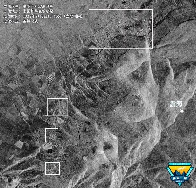
Istanbul, Türkiye, at 4:17 am local time on February 6 in Europe, an earthquake of magnitude 7.7 occurred in Türkiye's Kahlamamarash province, followed by at least 185 aftershocks in the southeast of the country and its surrounding areas. Under the circumstance that the disaster situation in the disaster area is unknown and aftershocks continue to occur, remote sensing satellites have become the main means to obtain the disaster situation in the disaster area. Global Times reporter learned from Tianyi Research Institute of China Commercial Satellite Corporation on February 7 that after the Türkiye earthquake, Tianyi Research Institute arranged Chaohu 1 satellite to take emergency imaging of the earthquake stricken area as soon as possible, and successfully obtained the radar remote sensing image of the surrounding area of the earthquake at 11:05 local time on February 6, Türkiye.
ESRI discloses historical optical satellite images before Türkiye earthquake
SAR satellite image of Türkiye earthquake area taken by Tianyi Chaohu 1 SAR satellite
It is understood that the Chaohu 1 satellite used the strip mode this time, with an imaging area of about 8878 square kilometers. After obtaining the satellite image of the epicenter of the Türkiye earthquake, the researchers of the Tianyi Research Institute analyzed the post earthquake image in combination with the previously published local optical satellite image before the earthquake, used SAR image to image the building, and judged that the residential area (Sakchage Ju) about 3000 meters away from the source was significantly damaged. The mountain near the source is suspected to have geological disasters.
According to several foreign media reports, the two strong earthquakes in the Türkiye earthquake occurred in the province of Kahramanmalash. There were many cities near the epicenter, and the largest cities in southeast Türkiye, such as Gaziantep and Kahramanmalash, were seriously damaged. The earthquake has killed more than 4300 people in Turkey and Syria. Among them, the death toll from the earthquake in Türkiye has risen to 2921.
According to the reporter of the Global Times, optical satellite imaging is difficult because of the bad weather and thick clouds in the epicenter of the earthquake on the day of the accident. Therefore, synthetic aperture radar (SAR) with all-weather working ability is an important means to obtain panoramic images of the earthquake disaster area. In the future, Tianyi will continue to pay attention to the situation in the earthquake area and provide satellite image support for the rescue work in the earthquake disaster area.
(The above quotes are reported by Chinese media. Please indicate the source of information for reprinting.)
As a member of ICC Member, QCIT Group now appeals to members from all over the world of ICC to cooperate with our company, and join hands with our group team to lend a helping hand to earthquake stricken areas in Türkiye. At this moment, the COVID-19 is just coming to an end, but the earthquake disaster is happening in Türkiye. QCIT Group has provided relevant assistance to local customers and partners, which relevant materials and equipment will be collected and sent to the local area in coming week. A single spark can start a prairie fire, we hope that all business people around the world can overcome barriers, make a better future together, and do contributions to the recovery of the world economy within their ability. Thanking you...


